Blog New Digital System Helps Ethiopia’s Pastoralist Communities to Prepare for the Unpredictable
A new web-based platform with information on water and pasture availability is digitizing climate resilience for Ethiopia's pastoralists.
By: Sintayehu Alemayehu, Sintayehu Workeneh, Getachew Tegegn, Tadesse Terefe, Lidya Tesfaye, Liyuneh Gebre
The rangelands covering more than half of Ethiopia’s landmass feed the country’s cattle, providing incomes for the country's many pastoralist communities. Yet, this land faces growing acute insecurities, having faced eight major droughts in the past 15 years. This cumulative disruption to pasture and water availability has caused mass livestock death, including over 4.5 million animals in 2022 alone, impacting food security and livelihoods, and causing the displacement of many communities in search of reliable food and income sources.
Facing increasingly frequent and severe climate impacts, pastoralist communities and government agencies require support to make decisions that benefit livestock, communities and Ethiopia as a whole.
To address this need, the Alliance collaborated with Ethiopia's Ministry of Agriculture and the Ethiopian Institute of Agricultural Research (EAIR), developing the innovative 'Waterpoints Monitoring' platform. The platform - part of the Livestock Water Monitoring and Risk Management System (LWMRMS) Project funded by the Bill & Melinda Gates Foundation - aims to build resilience in vulnerable pastoralist communities by supporting their adaptation to challenging climatic challenges.
The pasture, water and climate monitoring platform was developed to support gender and socially inclusive drought risk management, aiding decision-making through the provision of near real-time information to livestock farmers and other stakeholders across Ethiopia.
The lack of access to timely and comprehensive data is affecting Ethiopian pastoralists' ability to adapt to climate change.
Sintayehu Alemayehu - Research Team Leader at Alliance - leads the LWMRMS Project, and was one of the scientists behind the new platform’s development. Born and raised in Moyale, Ethiopia - an area home to many pastoralist communities - Alemayehu knows well the challenges faced by the region’s livestock producers: “I understand what the pastoralist context is, what the gaps and the challenges are,” Alemayehu said. “It’s heartbreaking to witness the community facing the worst drought in its history.”
With the largest livestock population in Africa, Ethiopia's livestock sector contributes significantly to the country’s economy, accounting for 15% of export earnings and 36% of agricultural gross domestic product. However, due to changing weather patterns, many livestock producers in Ethiopia are unable to rely on the same water and pasture sources as before, placing growing pressure on what were traditionally more reliable sources of nutrition, incomes, and livelihoods. To protect their livestock, pastoralists need the resources to make informed decisions, manage risks, and strengthen their resilience to the impacts of climate change.
Pastoralist communities have not traditionally had access to a livestock early warning information system that could predict and provide comprehensive information on water and pasture availability. This lack has limited the ability of pastoralists, the national government and other development partners to navigate pressing climate challenges.
The Waterpoints Monitoring platform is filling this data gap, equipping pastoralists in Ethiopia with near real-time information to improve adaptation to climate challenges.
The Waterpoints Monitoring platform integrates real-time data sourced through a variety of remote sensing techniques such as satellite rainfall estimates, among others, to provide insights into water resource management, as well as calibrated and validated hydrological and water balance models to simulate water levels at each waterpoint.
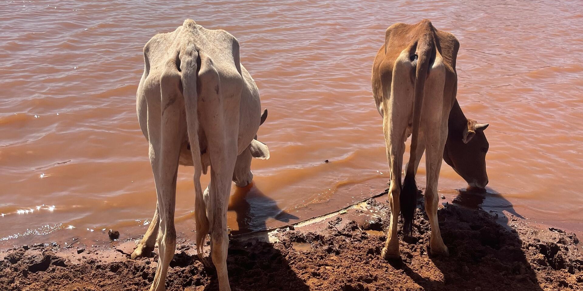
Cattle drinking from a waterpoint. Reliable, data-driven information on waterpoint locations and water levels is vital to ensure climate resilience for Ethiopia's pastoralists. Photo credit: S. Alemayehu (Alliance Bioversity International - CIAT)
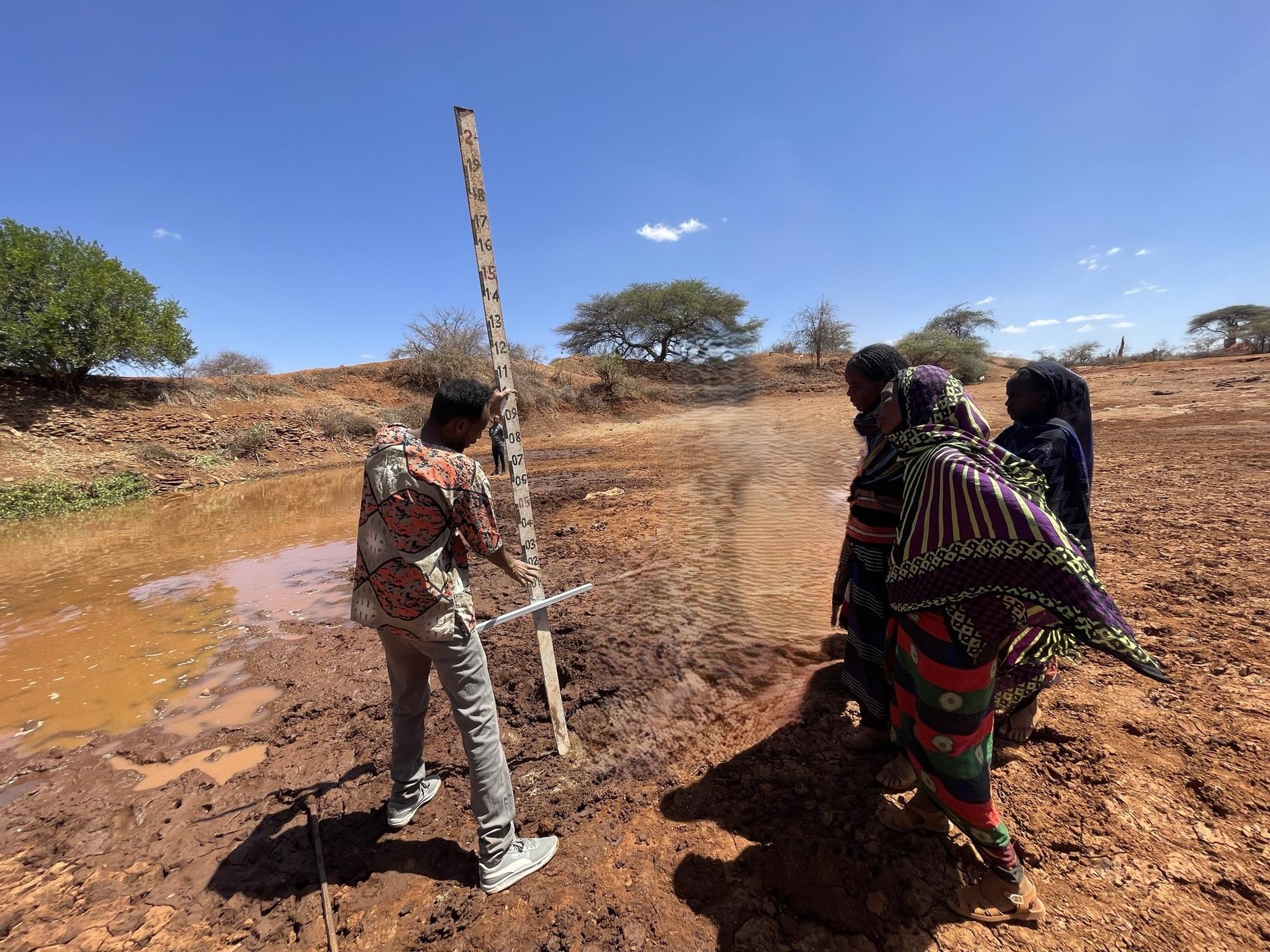
To calibrate and validate the hydrological model, gauging stations have been strategically placed at various waterpoints to directly measure water levels in real time. This measured data is then used to fine tune and validate the platform’s ability to accurately simulate water depths.
Using the model, individuals are able to access site-specific information on the relative depth, rainfall, and evaporation level of the water surface: vital information for pastoralists managing a thirsty herd.
The platform also shows users how long it will take to travel to reach available resources, helping pastoralists to anticipate forage shortages and move their cattle to more abundant areas. Perhaps most importantly, the platform also provides up to six months’ worth of forecasts, giving pastoralists and government agencies the ability to plan ahead, despite the increasingly unpredictable weather patterns.
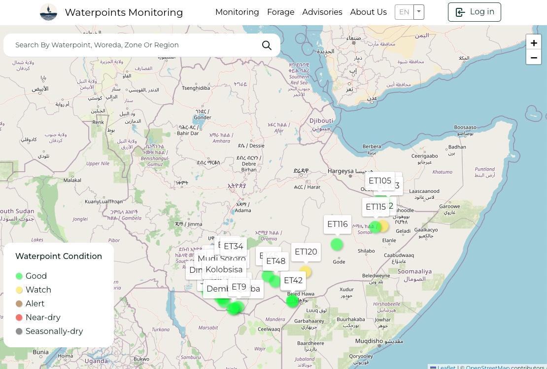
One of the interactive maps available on the Waterpoints Platform shows the condition of different water points across Ethiopia.
The team behind the project also paid close attention to addressing the specific challenges pastoralists face. As such, a human-centred approach - which incorporates Indigenous people's knowledge and the know-how of the region’s pastoralist communities - has been central to the platform’s development. This focus on ensuring the platform’s accessibility for its users on the ground has extended to the information it supplies.
The team has also established a Pastoralist Community of Practice (PCoP), which acts as a nexus for collaboration, information sharing, and collective action. The participation of key stakeholders in the PCoPs - including pastoral communities, researchers, and policymakers - enables the generation of knowledge and the establishment of a two-way feedback system. Through the PCoPs, pastoralists, experts, and other stakeholders collaborate to share information and provide timely updates on pasture and water conditions.
This vital information is disseminated through various channels, such as radio and television programs, SMS, printed materials, community meetings, and information boards to efficiently reach at-risk communities. As a result, the platform provides data that is both highly relevant and highly accessible and actionable for pastoralists.
As a native of the region and reflecting on the need to equip pastoralists with accessible information to improve their decision-making amid rising challenges, Alemayehu said: “I am using the education I have obtained to give back to my community through this project.”
Enhancing collaborative efforts for early warning and decision-making in Ethiopia
The Waterpoints Monitoring platform has been co-designed from its inception with the Ethiopian government, that now fully owns the product and is leading the outreach to local pastoralist communities.
The platform also holds the potential to be adapted and used by a range of actors beyond the region’s pastoralist community. According to Alemayehu: "each sector can use this information to inform from different angles”.
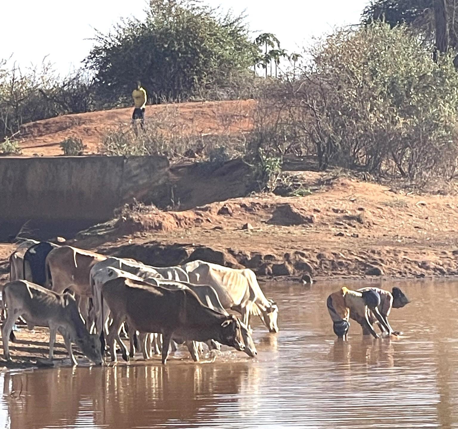
Cattle drink from a waterpoint. Reliable, data-driven information on water point locations and water levels is vital to ensure climate resilience for Ethiopia's pastoralists. Photo credit: S. Alemayehu/Alliance Bioversity International and CIAT
Alemayehu highlights how for governments and NGOs, the platform’s predictive data and forecasts can help better fine tune policy and humanitarian interventions ahead of droughts and related threats. In the private sector, the platform can also be used to enhance market linkages between Ethiopia’s pastoralists and cattle feed producers, particularly as they navigate various complex climate and resource challenges.
What’s next?
The Livestock Water Monitoring and Risk Management System (LWMRMS) project team is now raising awareness and training pastoralists to use the Waterpoints Monitoring platform, while building a community information center to continue engaging pastoralists.
Additionally, the team is working with the Ethiopian government and other stakeholders to upscale and to incorporate the pasture monitoring in the platform into their livestock insurance interventions. Speaking about the future of the project, Alemayehu called for a multisector approach, highlighting how the platform can be adapted for different uses and needs, saying: “our work is scalable and there is always room for improvement, collaboration, and partnership.”
The launch of the user-centered integrated water, pasture, and climate monitoring and forecasting system represents a significant step towards digitizing resilience for the pastoralist communities of Ethiopia and beyond.
Now, in the face of the impacts of climate change, Ethiopia’s pastoralists can plan more effectively, thus safeguarding their livelihoods and the food security they provide to communities across the country.
Acknowledgements
The Livestock Water Monitoring and Risk Management System (LWMRMS) is a collaborative effort made possible through the support and partnership of several key organizations. We would like to express our sincere gratitude to our funders the Bill and Melinda Gates Foundation, Ministry of Agriculture, Ethiopia and Ethiopian Institute of Agricultural Research (EAIR) for their invaluable partnership in making this work a reality.
The Team

Sintayehu Workeneh Dejene
Research Management Coordinator
Getachew Tegegne
Research Project Coordinator - Climate Change and Water Resources Management
Tadesse Terefe Zeleke
Research Project Coordinator - Climate Change and Water Resources Management
Lidya Tesfaye
Research OfficerSee Also