
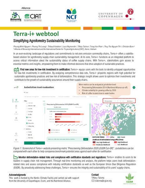
Terra-i +

Terra-i+ is an advanced satellite-based analysis tool designed to help key commodities operators enhance the compliance of their supply chains. By enabling assessments for compliance with the European Union Deforestation Regulation (EUDR) and other certification standards, Terra-i+ supports informed decision-making and promotes opportunities for agroforestry and shade tree coverage.
The tool is currently being piloted in Vietnam's coffee industry, where it was co-designed with coffee traders to address specific supply chain challenges.
With the ability to integrate high-precision, localized datasets into customized metrics and a user-friendly interface, Terra-i+ offers versatile functionality. It can perform analyses at the jurisdictional level or use user-uploaded farm data, providing insights that can be easily exported in multiple formats.
Terra-i+ adheres to strict validation standards, achieving exceptional accuracy for key land cover categories such as coffee and natural forests, with precision and recall rates ranging from 80% to 90%.

Screenshot of metric Likelihood of Non-Compliance With EUDR
In what context is this tool useful?
The tool helps operators and traders of key commodities, such as coffee and cocoa, to make informed decisions for managing deforestation risks within their supply chains. By aligning with carbon commitments and sustainability goals, the tool supports efforts to reduce global deforestation and lower carbon footprints.
Results achieved and expected
By 2030, Terra-i+ will have enabled the sequestration of at least 4,375 tonnes of CO2 equivalent in above-ground biomass. This achievement is driven by the planting of over 150,000 trees as part of the coffee agroforestry initiative implemented by Terra-i+’s first registered industry user, ECOM SMS Vietnam.
The calculation is based on the conservative methodology outlined by Chave et al. (2014) and incorporates a 44% tree mortality rate, as reported by Banin et al. (2022).
Variations, scaling and adaptations
The Terra-i+ web tool is designed to be scalable and replicable across various geographies and commodities.
Initially piloted in Vietnam's coffee sector, Terra-i+ is part of a broader global vision to create an Inclusive Reference Dataset and a shared public digital infrastructure for highly accurate, inclusive maps. This global dataset aims to reduce the cost of developing localized, high-accuracy maps, enhance the transparency of sustainability reporting processes, and prevent the exclusion of smallholders from key markets caused by map misclassification.
Contact us

Nguyen Minh Phuong
Research Associate
Tiffany Talsma
Team co-Lead, Data Driven Sustainability
Thibaud Vantalon
Postdoctoral Fellow
Phuong Luong
GIS Analyst
Christian Bunn
Scientist II
Fabio Castro-Llanos
Senior Research AssociateTerra-i+: Satellite based solution for Agroforestry Supply Chain Sustainability
Webinar Terra-i+: A Satellite-based Solution for Agroforestry Supply Chain Sustainability
This webinar gives a behind-the-scenes look at Terra-i+, a tool developed for and with the private sector, enabling coffee companies to make informed decisions about their supply chain. Integrating high precision localized dataset into tailored metrics and user-friendly interface, the tool has the capacity to analyze both at jurisdiction level and on user-upload farm data, as well as exporting the analysis into multiple formats.
More publications
Funders
Funding and Partnerships
-
Funding:
-
The development of the Terra-i+ tool was supported by the Development Fund.
-
-
Project Partners:
- University of Copenhagen
- Rainforest Alliance
- Ecom Agroindustrial