Now reading: vulnerability mapping for forest conservation and restoration
A new article presents a vulnerability mapping model turned online tool, that contributes to science-based planning for forest restoration and conservation.
Over the last two decades, forest conservation and restoration has emerged as one of the leading science-based efforts to mitigate human pressures on the earth’s ecosystems. However, the planning and coordination of these efforts are complex, because individual species respond differently to the variety of anthropogenic forces that threaten forest landscapes. Fortunately, that’s exactly the challenge that motivates vulnerability mapping efforts. This month, Tobias Fremout, a PhD candidate at the University of Leuven in Belgium, alongside Alliance scientists Evert Thomas and Rachel Atkinson, publishedan article in the journal of Global Change Biology that presents their spatial and species-specific vulnerability mapping model for the tropical dry forest of northwestern Peru. The publication not only summarizes important insights for forest restoration in this very unique and endangered landscape, but also presents a novel approach to vulnerability mapping that could inform similar efforts around the world.
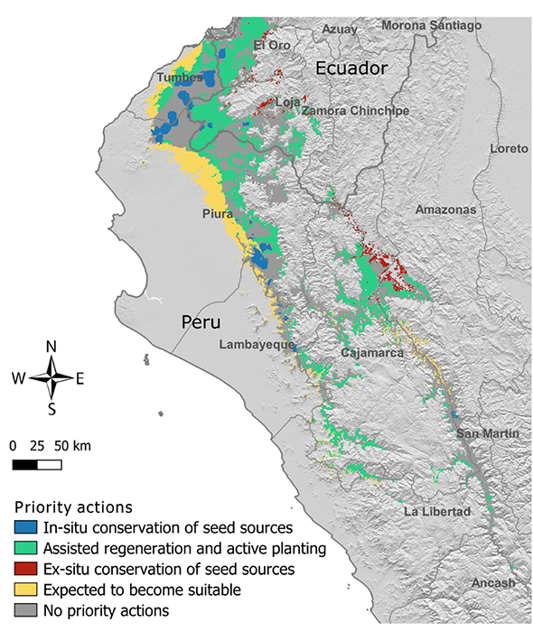
Their model evaluates how the anthropogenic threats of overexploitation, overgrazing, forest fires, habitat conversion, and climate change affect 50 of the most common tree species in the tropical dry forest of northwestern Peru and southern Ecuador. The results demonstrate that the threats are alarming—nearly half (46%) of the predicted species’ distributions were found to be highly or very highly vulnerable to one or more of the threats. Furthermore, their results suggest that current levels of overgrazing, habitat conversion, and overexploitation pose higher risks to the tree species than the looming threat of climate change. In other words, restoration and conservation actions need to be in place for the very near future, not several decades from now. With this much of a highly endemic ecosystem at risk, the team set out to make their findings more applicable. Based on the vulnerability assessment results, they proposed three types of species-specific restoration and conservation actions:
- in-situ conservation of tree populations and seed collection for tree planting activities in areas with low vulnerability to climate change and current threats,
- ex-situ conservation or translocation of populations in areas with high climate change vulnerability
- active planting or assisted regeneration in areas under high current threat vulnerability but low climate change vulnerability, provided interventions are in place to lower threat pressure.
This approach was applied to the distribution of each species in order to generate priority action maps, like the one shown at the top of this page.
What makes this methodology different?
While the scientific process should always be kept in high regard when generating models that lead to action recommendations, models are still made by people, and therefore, there’s more than one way to do it. Fremout et. al’s methodology varies from others through its vulnerability assessment, and specifically, the use of species’ traits to assess sensitivity. Sensitivity calculations are what quantify how the survival and reproduction of the individual species will be affected by each different anthropogenic threat. Previous models have used expert opinions to assign sensitivity values, but this means that the model is dependent on the expert’s concept of sensitivity. In addition, this method is difficult to apply in understudied ecosystems, where only very few experts may know the local flora well enough to assess the sensitivity.
Alternatively, Fremout et al. estimated the sensitivity of species using a set of traits that are relevant to the given threats. For example, previous studies have found that bark thickness and growth rate, among other traits, affect tree sensitivity to forest fires. Therefore, data on bark thickness, growth rate, and other traits can be collected; traits can be statistically weighted according to their expected influence on the species’ sensitivity to fire; and a sensitivity score can be calculated accordingly. This method seems to make the model more transparent and scalable, and therefore it could potentially be extended to other ecosystems and countries, provided that the necessary spatial data and trait data are available. Furthermore, other threat factors or specific traits could be added to adapt the model to various local realities.
Currently, Fremout et al. are working to integrate the species-specific priority action maps into the Diversity for Restoration online tool, which was developed for the Colombian tropical dry forest in 2016. Now, anybody interested in tree planting activities for the tropical dry forest in Peru, Ecuador, or Colombia, can input their project’s coordinates and objectives to the D4R platform and subsequently receive detailed recommendations on which species to plant and where to collect seeds. The D4R team also anticipates that the work of colleague Jessica Cerrón will be linked to the D4R tool. Her work catalogs the previous and current restoration efforts throughout northwestern Peru and would greatly refine the tool’s ability to suggest nearby seed sources that coincide with planting recommendations.
Historically, species selection decisions for restoration projects in the tropical dry forest of northwestern Peru have been largely opportunistic. This results in the frequent use of a limited number of well-known species, which are not necessarily well-matched to restoration objectives, nor well-adapted to a planting site’s stress conditions. The main goal of the D4R tool is to integrate existing data to support science-based decisions on species selection and seed sourcing. While the tool can be used by anybody who is interested in planting trees for whatever purpose, it aims at facilitating more diversity in species selection by making information about lesser-known species more-readily available and in a format that is easy to use.
What comes next?
Currently, the D4R tool is being expanded into Africa, where researchers within the Alliance network are starting to collect the necessary trait data in Burkina Faso and Cameroon. Meanwhile, in Southeast Asia, the development of a seed collection and distribution program has been a priority for several years. While D4R has not yet integrated distribution features, it is a conceptual starting point for the development of digital seed exchange programs. What is perhaps most significant is that as this type of vulnerability mapping and online platform inform similar efforts around the world, the adaptability and scalability to local needs are prioritized. When it comes to restoration and conservation, there are certainly shared global challenges, but it is important that science-based solutions focus on providing useful tools and thorough information to the local stewards of each unique landscape.
This research is conducted as part of the CGIAR Research Program on Forest, Trees and Agroforestry (FTA), is supported by contributors to the CGIAR Trust Fund, and is made possible also by VLIR-UOS, the German Federal Ministry of Economic Cooperation and Development (BMZ) and the University of Leuven.