
Climate-Smart Mapping and Adaptation Planning (CS-MAP) of four provinces in Vietnam’s South Central Coast
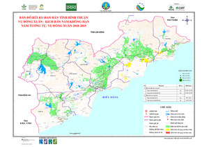
The Climate-Smart Mapping and Adaptation Planning (CS-MAP) initiative in South Central Coast of Vietnam aimed to support the direction and administration of water supply for agricultural production, and prevent and combat droughts for rice and annual crop areas in the region. Using the CS-MAP approach, the Department of Crop Production, together with CCAFS SEA, Alliance of Bioversity International and CIAT, Institute of Water Resources Planning, and local stakeholders, produced a set of drought risk maps and production adaptation maps. The maps were developed for three cropping seasons (i.e. winter-spring, summer-autumn, and autumn) and three water source scenarios. The adaption plans identified by the research team and the stakeholders are: concentration of production areas, conversion from normal crops to drought-tolerant crops, early planting (in flood-prone areas) and late planting (in drought-prone areas), and conversion of crop structure.